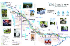
Cache la Poudre National Heritage Area Overview Map – Print Friendly PDF
ROUTE DESCRIPTION
The Heritage Area extends for 45 miles and includes the lands within the 100-year flood plain of the Cache la Poudre River. It begins in Larimer County at the eastern edge of the Roosevelt National Forest and ends east of Greeley, ¼ miles west of the confluence with the South Platte.
 |
 |
 |
© 2024 Cache la Poudre River National Heritage Area.
Web design by Mt. Bailey Productions | Privacy Policy
Photography by Gabriele Woolever unless otherwise credited.


